
 Image 1 of 4
 Image 2 of 4
 Image 3 of 4
 Image 4 of 4
📥 Download FREE desktop wallpaper
🖼️ View artwork details & shipping
📸 Request a free wall preview
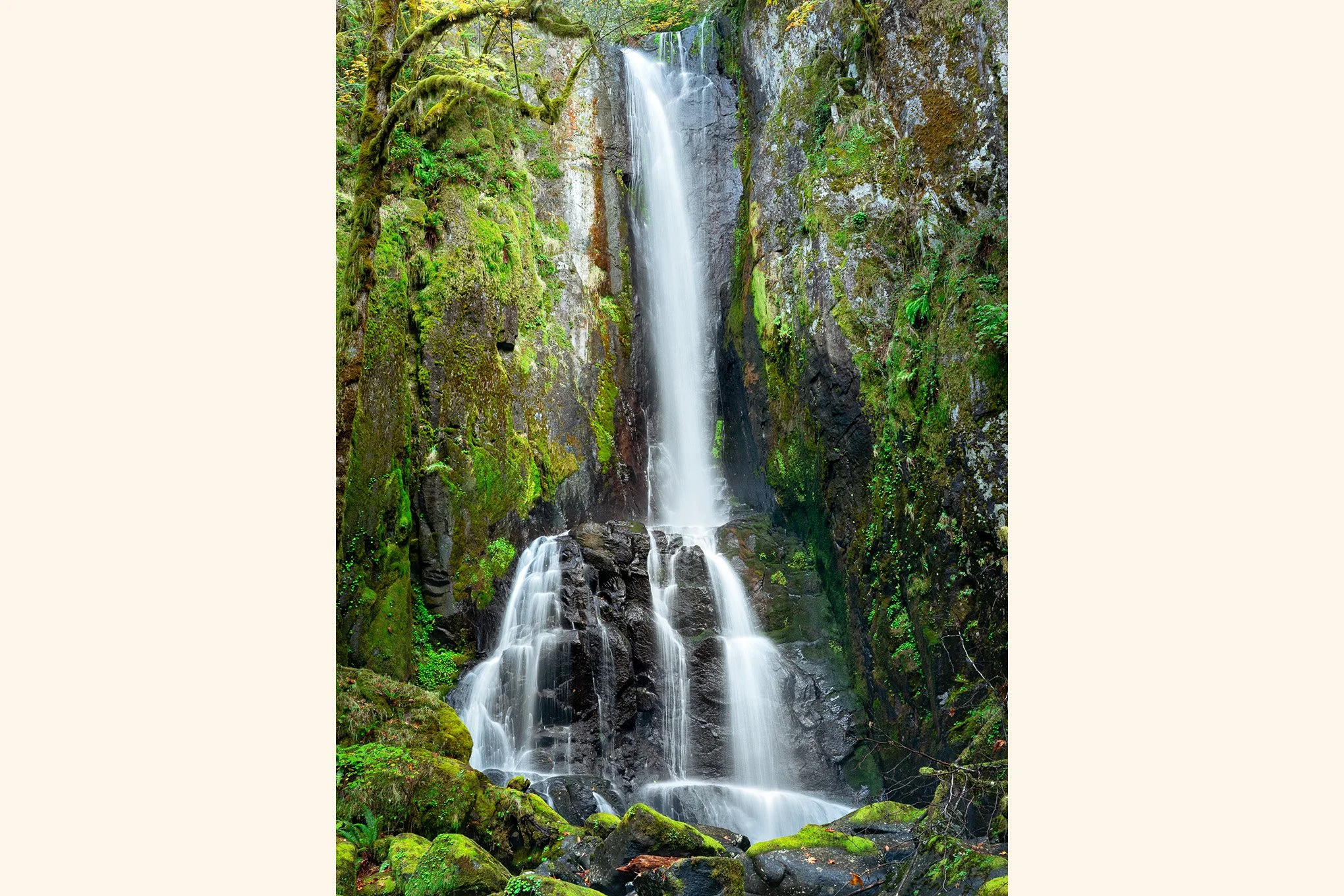
“Lower Kentucky Falls”
Description:
Located in the central coast range of Oregon between Florence and Eugene, Lower Kentucky Falls, photographed here in late October, is at the end of a 4.4 mile out-and-back hike. While the hike is moderate, getting to the trailhead is not. It requires driving on logging roads where the grade can be as steep as 20%.
Story:
Lower Kentucky Falls plunges 90 feet before weaving through moss-draped rock.
Trusting Google Maps to get me here became an adventure of its own. A wrong turn three miles before the trailhead sent me down a single-lane road swallowed by overhanging vegetation. For a moment, I felt like Indiana Jones rattling through some misty jungle — just in a CR-V, not a jeep.
Deep in the Oregon Coast Range, roughly halfway between Florence and Eugene, both Lower and Upper Kentucky Falls were worth the bushwhacking detour and the maze of active logging roads.
The trail itself was narrow and hugged the edge of a ravine where vine maples glowed yellow, ready for the next cold snap to shake them bare. Towering old-growth Douglas firs stood like pillars holding up the sky — a small sanctuary carved into a landscape otherwise laced with roads.
The sound of the falls was a constant companion, an echo in the trees that made it easy to forget I had driven over three hours through civilization to reach this pocket of quiet. Morning chill hung in the air — that familiar coastal-range mix of cold and humidity — sharpening the forest’s scents: sweet pitch, damp earth, and the musky perfume of duff. Each breath pulled me deeper into the woods.
-BAP
Location:
Lower Kentucky Falls
Kentucky Falls Trail #1376
Oregon Coast Range
43° 55' 51.1'' N, 123° 49' 3'' W
Google Map Link
Time: 11:17 PDT (morning)
Date: October 24th, 2020
Camera & Settings:
Single Shot
Nikon D800E, NIKKOR 24-70 f/2.8G, CPL filter, tripod
ISO 320, 40 mm, f/11, 0.5 sec
📥 Download FREE desktop wallpaper
🖼️ View artwork details & shipping
📸 Request a free wall preview
“Lower Kentucky Falls”
Description:
Located in the central coast range of Oregon between Florence and Eugene, Lower Kentucky Falls, photographed here in late October, is at the end of a 4.4 mile out-and-back hike. While the hike is moderate, getting to the trailhead is not. It requires driving on logging roads where the grade can be as steep as 20%.
Story:
Lower Kentucky Falls plunges 90 feet before weaving through moss-draped rock.
Trusting Google Maps to get me here became an adventure of its own. A wrong turn three miles before the trailhead sent me down a single-lane road swallowed by overhanging vegetation. For a moment, I felt like Indiana Jones rattling through some misty jungle — just in a CR-V, not a jeep.
Deep in the Oregon Coast Range, roughly halfway between Florence and Eugene, both Lower and Upper Kentucky Falls were worth the bushwhacking detour and the maze of active logging roads.
The trail itself was narrow and hugged the edge of a ravine where vine maples glowed yellow, ready for the next cold snap to shake them bare. Towering old-growth Douglas firs stood like pillars holding up the sky — a small sanctuary carved into a landscape otherwise laced with roads.
The sound of the falls was a constant companion, an echo in the trees that made it easy to forget I had driven over three hours through civilization to reach this pocket of quiet. Morning chill hung in the air — that familiar coastal-range mix of cold and humidity — sharpening the forest’s scents: sweet pitch, damp earth, and the musky perfume of duff. Each breath pulled me deeper into the woods.
-BAP
Location:
Lower Kentucky Falls
Kentucky Falls Trail #1376
Oregon Coast Range
43° 55' 51.1'' N, 123° 49' 3'' W
Google Map Link
Time: 11:17 PDT (morning)
Date: October 24th, 2020
Camera & Settings:
Single Shot
Nikon D800E, NIKKOR 24-70 f/2.8G, CPL filter, tripod
ISO 320, 40 mm, f/11, 0.5 sec