 Image 1 of 4
 Image 2 of 4
 Image 3 of 4
 Image 4 of 4
📥 Download FREE desktop wallpaper
🖼️ View artwork details & shipping
📸 Request a free wall preview
“Cold Blast”
Description:
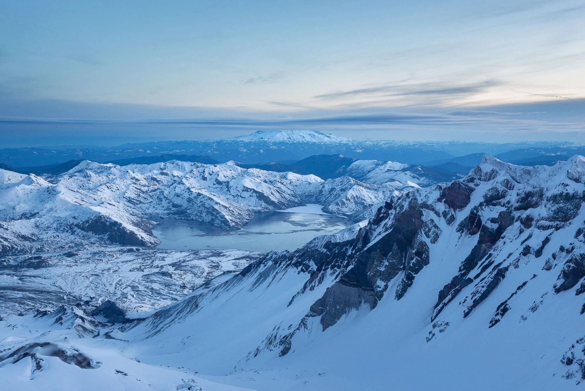
The summit of Mount St. Helens overlooks the crater carved by the 1980 eruption that blasted out the volcano’s northern side, seen here in winter during blue hour with Spirit Lake and Mount Rainier in the distance. The non-technical climb attracts hikers and backcountry skiers year-round. Once called the “Fuji of the West,” Mount St. Helens remains visually captivating.
Story:
Looking north from the crater rim of Mount St. Helens, a broad sweep of volcanic rock and snow leads toward Spirit Lake and, in the distance, Mount Rainier — its summit hidden behind a restless layer of cloud.
The cold was brutal. A north wind sharpened every gust, biting at any exposed skin. My fingers moved with the speed and grace of a sedated cheetah as I worked to unpack my gear and set up the camera. Even the smoldering lava dome in the crater looked like a tempting hot spring from where I stood. (Definitely not an option unless you enjoy immediate death.)
Between adjustments, I shoved my hands into thick mittens, trying to keep enough warmth in my fingertips to finish setting up.
I had reached the summit only twenty minutes earlier after a six-hour climb from the Marble Mountain Sno-Park. I started hiking around 1:00 AM, determined not to arrive too early like I had on South Sister five months before. The ascent was a long winter grind. Without full-shank boots, I spent most of the climb on the balls of my feet, letting my crampons dig into the hardened, well-traveled snow.
Around 3:30 AM I passed a camp just waking up at the timberline, their headlamps glowing inside frost-coated tents. Seeing the full slope above me for the first time, I noticed no lights ahead. I would reach the summit before anyone else that morning, but I wouldn’t be climbing it alone.
As I continued upward, more headlamps appeared far below, slowly weaving their way up the mountain. Conditions were perfect for climbing, and plenty of people knew it.
Photography conditions, however, weren’t on my side. Mount Rainier was completely shrouded in clouds. Still, standing on that crater rim in the teeth of the cold, I felt nothing but relief and accomplishment. I’d reached another summit with a camera strapped to me the whole way — that extra weight takes a toll.
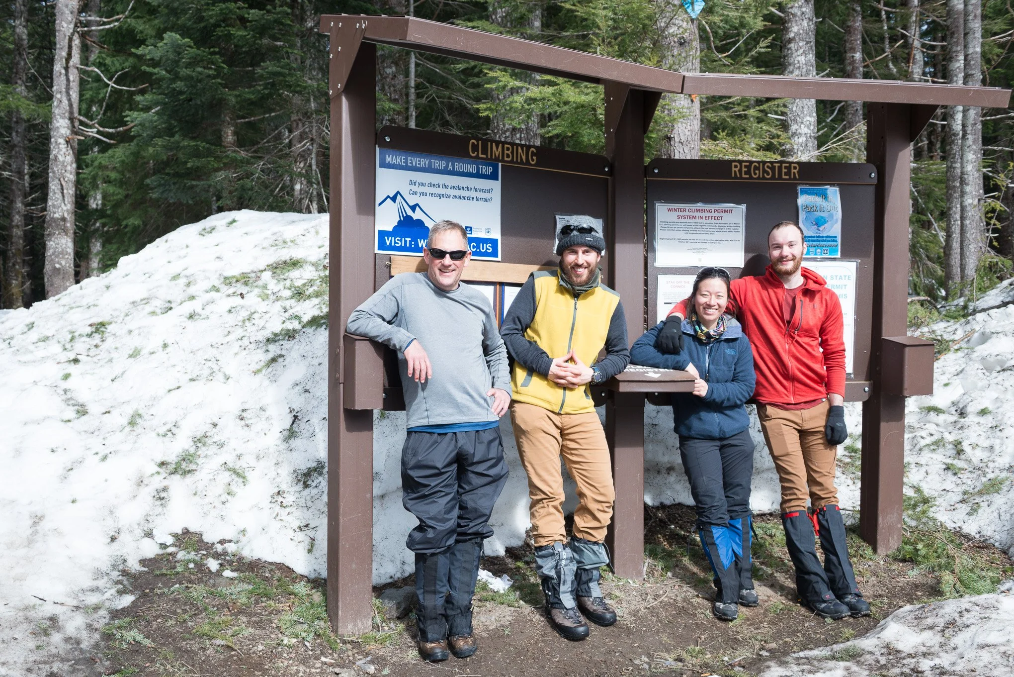
But the climb wasn’t the best part. The hikers I passed in the dark at timberline reached the top not long after I did, and by the time we descended together after sunrise, we were already trading stories. Those strangers became great friends, and we still keep in touch.
Bitter cold. Brutal climb. Rainier blocked by clouds.
Still one of the best mornings I’ve ever had and I think the photograph still turned out great!
-BAP
Location:
Summit of Mount St. Helens
Worm Flows Route
Washington
46° 11' 23.6'' N, 122° 11' 20.3'' W
Google Map Link
Time: 07:13 PDT (sunrise 07:31)
Date: March 10th, 2020
Camera & Settings:
Single shot
Nikon D800E, NIKKOR 24-70 mm f/2.8G, CPL filter, Tripod
ISO 100, 38 mm, f/10, 2.5 sec
📥 Download FREE desktop wallpaper
🖼️ View artwork details & shipping
📸 Request a free wall preview
“Cold Blast”
Description:
The summit of Mount St. Helens overlooks the crater carved by the 1980 eruption that blasted out the volcano’s northern side, seen here in winter during blue hour with Spirit Lake and Mount Rainier in the distance. The non-technical climb attracts hikers and backcountry skiers year-round. Once called the “Fuji of the West,” Mount St. Helens remains visually captivating.
Story:
Looking north from the crater rim of Mount St. Helens, a broad sweep of volcanic rock and snow leads toward Spirit Lake and, in the distance, Mount Rainier — its summit hidden behind a restless layer of cloud.
The cold was brutal. A north wind sharpened every gust, biting at any exposed skin. My fingers moved with the speed and grace of a sedated cheetah as I worked to unpack my gear and set up the camera. Even the smoldering lava dome in the crater looked like a tempting hot spring from where I stood. (Definitely not an option unless you enjoy immediate death.)
Between adjustments, I shoved my hands into thick mittens, trying to keep enough warmth in my fingertips to finish setting up.
I had reached the summit only twenty minutes earlier after a six-hour climb from the Marble Mountain Sno-Park. I started hiking around 1:00 AM, determined not to arrive too early like I had on South Sister five months before. The ascent was a long winter grind. Without full-shank boots, I spent most of the climb on the balls of my feet, letting my crampons dig into the hardened, well-traveled snow.
Around 3:30 AM I passed a camp just waking up at the timberline, their headlamps glowing inside frost-coated tents. Seeing the full slope above me for the first time, I noticed no lights ahead. I would reach the summit before anyone else that morning, but I wouldn’t be climbing it alone.
As I continued upward, more headlamps appeared far below, slowly weaving their way up the mountain. Conditions were perfect for climbing, and plenty of people knew it.
Photography conditions, however, weren’t on my side. Mount Rainier was completely shrouded in clouds. Still, standing on that crater rim in the teeth of the cold, I felt nothing but relief and accomplishment. I’d reached another summit with a camera strapped to me the whole way — that extra weight takes a toll.
But the climb wasn’t the best part. The hikers I passed in the dark at timberline reached the top not long after I did, and by the time we descended together after sunrise, we were already trading stories. Those strangers became great friends, and we still keep in touch.
Bitter cold. Brutal climb. Rainier blocked by clouds.
Still one of the best mornings I’ve ever had and I think the photograph still turned out great!
-BAP
Location:
Summit of Mount St. Helens
Worm Flows Route
Washington
46° 11' 23.6'' N, 122° 11' 20.3'' W
Google Map Link
Time: 07:13 PDT (sunrise 07:31)
Date: March 10th, 2020
Camera & Settings:
Single shot
Nikon D800E, NIKKOR 24-70 mm f/2.8G, CPL filter, Tripod
ISO 100, 38 mm, f/10, 2.5 sec