
 Image 1 of 4
 Image 2 of 4
 Image 3 of 4
 Image 4 of 4
📥 Download FREE desktop wallpaper
🖼️ View artwork details & shipping
📸 Request a free wall preview
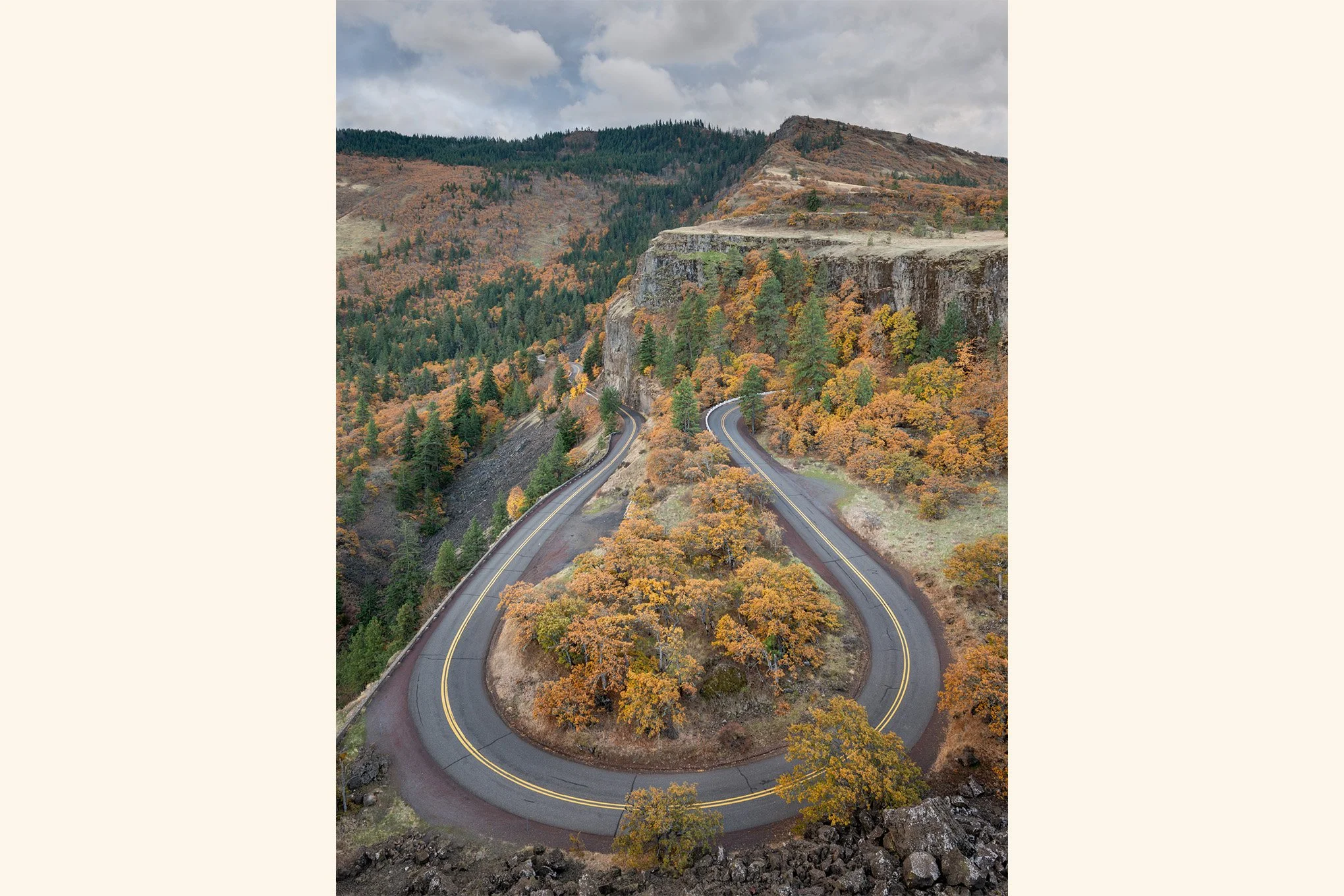
“Autumn Bend”
Description:
Completed in 1922, the Historic Columbia River Highway was the first planned scenic highway in the United States. Designed for beauty rather than speed, one of its most famous stretches is the sweeping horseshoe curve at Rowena Crest, perched between Mosier and The Dalles in the Columbia River Gorge.
Story:
The historic Columbia River Highway forms a dramatic hairpin turn at Rowena Crest in Mosier.
No matter the season, this viewpoint is one of those iconic Oregon locations that draws photographers and tourists alike. I was no exception and came here looking to photograph from a viewpoint that’s seen cars for nearly a century.
Autumn colors were particularly strong this year, and the muted oranges of the oak trees were at their peak. Built to be scenic, with beauty prioritized over commerce, the road snakes gracefully through the rocky terrain.
They don’t build them like they used to.
-BAP
Location:
Rowena Crest Viewpoint
Mosier, Oregon
45° 40' 55.6'' N, 121° 17' 57.4'' W
Google Map Link
Time: 16:14 PDT
Date: October 25th, 2019
Camera & Settings:
Single Shot
Nikon D800E, NIKKOR 14-24 mm f/2.8G, tripod
ISO 100, 24 mm, f/10, 1/8 sec
📥 Download FREE desktop wallpaper
🖼️ View artwork details & shipping
📸 Request a free wall preview
“Autumn Bend”
Description:
Completed in 1922, the Historic Columbia River Highway was the first planned scenic highway in the United States. Designed for beauty rather than speed, one of its most famous stretches is the sweeping horseshoe curve at Rowena Crest, perched between Mosier and The Dalles in the Columbia River Gorge.
Story:
The historic Columbia River Highway forms a dramatic hairpin turn at Rowena Crest in Mosier.
No matter the season, this viewpoint is one of those iconic Oregon locations that draws photographers and tourists alike. I was no exception and came here looking to photograph from a viewpoint that’s seen cars for nearly a century.
Autumn colors were particularly strong this year, and the muted oranges of the oak trees were at their peak. Built to be scenic, with beauty prioritized over commerce, the road snakes gracefully through the rocky terrain.
They don’t build them like they used to.
-BAP
Location:
Rowena Crest Viewpoint
Mosier, Oregon
45° 40' 55.6'' N, 121° 17' 57.4'' W
Google Map Link
Time: 16:14 PDT
Date: October 25th, 2019
Camera & Settings:
Single Shot
Nikon D800E, NIKKOR 14-24 mm f/2.8G, tripod
ISO 100, 24 mm, f/10, 1/8 sec